| |
The Turpan Depression
Thousands upon thousands of tourists flock to the Turpan Depression
in the season when the grapes ripen. An oasis stretching
across the ancient Silk Road, the Turpan Depression has a unique geographical
setting, and is a treasure-trove of ancient relics and fine products.
Records of Turpan appear in quite a number of ancient Chinese
books. Known as Gaochang, it was part of the territory of the State
of Cheshi, in the Han Dynasty, later becoming Gaochang Prefecture
in the Jin Dynasty, Xizhou Prefecture in the Tang Dynasty and Gaochang
Huihu in the Song Dynasty, while in the Yuan and Ming dynasties people
called it the "Fire Prefecture." The name "Turpan"
appeared for the first time in The History of the Ming Dynasty. During
the Qing Dynasty the government established a "Turpan
Provincial Department," and the name of Turpan has been used ever
since.
Ever since the Western Han Dynasty, more than 2,000 years ago,
Turpan has been the hub of communications between Central China and
its western frontiers, and from an early stage was deeply influenced
by the politics, economy and culture of the Central Plains. This has
been verified by a great deal of ancient literature and numerous archaeological
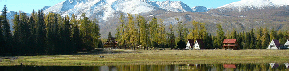
finds. Turpan is the deepest basin in China, and worldwide ranks second
only to the Dead Sea. It is surrounded by mountains rising over 1,000
meters, and to its north towers the grand and imposing snow-capped Mount
Bogda, 5,000 meters above sea level. A southward drive from Urumqi takes
one across the Tianshan Range to the plateau overlooking the Turpan
Depression, from where the view unfolds of a broad expanse of green
oases intermingled with yellow patches of desert. The Turpan Depression
covers an area of 10,300 square kilometers, half of it lying below sea
level. Lake Aydingkol is situated in the lowest part of the basin, and
its waters lie 154 meters lower than the level of the Yellow Sea to
the east. Not far from the lake looms a jagged mountain range extending
more than one hundred kilometers. Lying sprawled at the center of the
basin like a huge whale, it appears in the famous ancient novel Journey
to the West as the "Flaming Mountains." As a result of erosion,
not a blade of grass grows on this mountain, and the bare reddish-brown
sandstone is full of folds and wrinkles which shimmer under the refraction
of the blazing sun and hot air vapor, so that it looks as if flames
are dancing and leaping up to the sky. This is one of the fascinating
sights of the Turpan Depression. Turpan in summer is the hottest place
in China, which explains its name of "Fire Prefecture." From
June to August every year the average temperature is thirty degrees
centigrade, the highest in the
country, and for more than forty days in the year the temperature exceeds
forty degrees. At the height of summer, hot gusts blow and the surface
temperature of the gravelly ground reaches seventy degrees centigrade,
with the highest record at 82.3 degrees. People say they can cook eggs
by burying them in the sand and bake pancakes by putting them on the
wall.
For ten months of the year no rain or snow falls in Turpan. Annual rainfall
is less than sixteen millimeters whereas evaporation exceeds three thousand
millimeters per year. The air is so dry that mosquitoes and other insects
cannot breed and survive. In this kind of climate people have to drink
a lot of water, but evaporation rapidly dries up any sweat, and tourists
will not experience the discomfort of the sultry weather typical of
southern China. Although it is very hot at noon, a cool breeze blows
in the morning and evening, and a blanket is necessary if one sleeps
out in the open at night. The dry climate has helped preserve many ancient
relics, such as the 1,000-year-old corpses found at the ancient Astana
tombs at
the foot of the Flaming Mountains, ancient mural paintings, earthen
figurines, painted pottery and books, all of which have contributed
greatly to the study of ancient Xinjiang and exchanges between Chinese
and Western cultures. Turpan's unique environment is highly favorable
to cultivation. Records from the past say Turpan was a noted producer
of wheat
and other food, grapes, melons and other fruit, as well as cotton 1,000
years ago. Envoys, monks and men of letters who visited Turpan in the
Song, Yuan, Ming and Qing dynasties have left behind quite a number
of such accounts. Living in exile in Xinjiang, the national hero Lin
Zexu toured Turpan and wrote in his diary: "This is a fertile place,
which produces great quantities of cotton each year." Since liberation,
Turpan has been transformed. The local people have expanded their underground
irrigation system, sunk more than
3,000 new wells, dug ten irrigation canals and built eighteen reservoirs.
Tree-planting drives have added shelterbelts which crisscross new and
old oases, while poplar, elm, jujube, mulberry, peach, apricot, pear
and apple trees grow everywhere. Large numbers of new vineyards and
farms planting water melons and muskmelons have sprung up, and Turpan
is now a center for long-fiber cotton, Hami melons and seedless grapes
in Xinjiang.
The county seat of Turpan has been rebuilt as a political,
economic and cultural center, and has been opened to foreign
tourists in recent years. In the town the local Tourism Department has
built an elegant garden-like hotel in typical Uygur style. Summer and
fall are the best seasons for visiting Turpan.
Grape Valley
Most tourists who come to Turpan do not want to miss a visit to
Grape Valley, a mere thirty-minute drive from the Turpan County
seat. Grape Valley nestles in the western slopes of the Flaming Mountains,
northeast of the county seat. Like a silvery chain, a stream of water
rushes down for fifteen kilometers irrigating the whole valley, and
the slopes on both sides are covered with luxuriant vines as well as
mulberry, elm, peach and willow trees scattered here and there. Chatting,
laughing and singing, gaily-dressed Uygur girls move about in the green
foliage with their wicker baskets picking grapes. While it is sweltering
hot at the foot of the Flaming Mountains, a cool breeze blows all day
in Grape Valley. In the depths of the valley lies a guesthouse, where
tourists can relax and enjoy the scenery from elegant pavilions and
corridors under the shady grape trellises, where clusters of ripening
grapes hang. On one side of the guesthouse rises a steep cliff closely
covered with intertwined creeping wild vines. Springwater oozes from
crevices in the cliff and drips into a pool, where fish swim. Nearby
the hosts lay tables spread with every variety of grape, muskmelons
and their own wine for the enjoyment of their guests. The scene brings
to mind the story about the Monkey King in the ancient novel Journey
to the West, who stayed at the Flower and Fruit Mountain in a cave screened
by a curtain of water.After relaxing, guests may pay a visit to the
Flaming Mountains. On the denuded slopes are rows of honeycombed earthen
towers in which the local people hang up bunches of grapes to dry. Hot
gusts from the Flaming Mountains sweep through the perforations and
rapidly dry the grapes, turning them into raisins. A short climb further
up, affords tourists a bird's-eye view of the entire Grape Valley below
resembling a picture superbly embroidered on a velvet
carpet in the sun. Grape Valley has a population of more than 5,000
Uygur, Hui and Han people, who have been growing grapes and melons generation
after generation. The story goes that when Monk Xuan Zang of the Tang
Dynasty traveled west to seek scriptures, he and his disciples passed
through here. Stopping to rest, they drank from the mountain spring
and ate grapes that they had brought from far away, spitting the seeds
out on the ground. Later the seeds sprouted, grew into vines, and bore
the first grapes of the valley. As time went by they spread and turned
the valley into "The Land of Grapes." Of course, this is only
a fairy tale, but ancient Chinese literature claims that people around
the Flaming Mountains were growing grapes 1,000 years ago. Before Xinjiang
was liberated, all the land in Grape Valley was owned by seven landlord
households, and most of the peasants who cultivated the vines had to
pay exorbitant rents. They led a miserable life. After liberation, the
fruit growers became masters of Grape Valley, and supported by the people's
government which sent horticulturists to instruct them on how to improve
seed and increase output, they have expanded grape production. Today
Grape Valley has a total of 210 hectares of vineyards, most of which
is sown with the well-known seedless green grape variety, although red
grapes, black grapes and other kinds are also grown. Grape Valley produces
6,000 metric tons of grapes and more than 300 metric tons of raisins
per year, or three times the total output before liberation. The Turpan
Fruit Winery in the valley turns out a number of grape wines which sell
well across China.
The Flaming Mountains
In the ancient novel Journey to the West, the tale is told of how the
Monkey King borrowed a magic palm-leaf fan from Princess Iron Fan and
fanned the flames of the Flaming Mountains to put them out, so that
his master the Tang monk Sanzang could safely cross the mountain on
his way to seek Buddhist scriptures. Nowadays visitors to Turpan are
eager to visit the scene of this adventure. Driving alongside the Flaming
Mountains, tourists can feel hot gusts blowing on their faces, while
the ground temperature may reach eighty degrees centigrade. Geologists
say that the Flaming Mountains were formed 50-180 million years ago,
by magma bursting forth from under the sea during movement of the earth's
crust, while the ravines and gullies crisscrossing the slopes are the
result of erosion since those times. Under the blazing sun, the russet
sandstone sparkles, and hot vapor rises and coils like flames from a
great fire, which is how the mountains got their name. Although the
Journey to the West says "The mountain of flames extend for 800
Ii" (about 400 kilometers), the Flaming Mountains are in fact only
one hundred kilometers long, running east-west, and nine kilometers
wide. They range between 400 and 500 meters in height, the highest peak
being 851 meters above sea level. In the local Uygur language, the Flaming
Mountains are called Kiziltag meaning "Red Mountains." A local
legend complements the story in the Journey to the West. The legend
goes as follows:
In ancient times there was once an evil dragon which lived in the Tianshan
Mountains. Every so often it flew over to Turpan and demanded a little
boy and girl from the people there for its food. If the people refused
to give up their children, the dragon would fly into a rage and lay
waste to houses and farms, killing people and livestock. One day, however,
a young man named Karakhoja went to Turk Bughrahan and offered to rid
the people of this evil dragon. Sword in hand, he fought the dragon
for three days and three nights, and finally managed to cut the dragon
in two at Qijiaojing. The dying dragon tossed and rolled, its whole
body stained red with blood, while Karakhoja struck at it with his sword
again and again until it stopped moving. The dead dragon turned into
a red mountain, and the ten sword cuts turned into ten valleys ....
Today the ten "sword cuts" valleys .... are fertile fruit
growing areas, each with a flowing stream which irrigates the luxuriant
vines and trees. There are also ancient relics in these valleys grottoes,
mural paintings to name a few. Shengjinkou Valley, which runs across
the highest peak of the Flaming Mountains, provides a scene of sheer
precipices and strange craggy rocks, winding streams and
green meadows blooming with wild flowers. A natural stone pillar
stands on the top of the valley, where the local Uygurs say the Tang
monk Sanzang tethered his horse when he stopped here to rest on his
way to seek Buddhist scriptures. Not far from the valley are the ruins
of the famed ancient city of Gaochang.
Ancient men of letters described the area around the Flaming
Mountains as barren waste under the control of the God of Fire, but
today it is a land Of vigor and vitality. The local people have built
canals and ditches to bring water from the melted ice on the Tianshan
Mountains, so that they can expand the area of oases around the Flaming
Mountains.
Lake Aydingkol
Lying at the foot of the Qoltag Mountains on the borders of three counties
(Turpan, Shanshan and Toksun), forty kilometers from the Turpan County
seat, Lake Aydingkol stretches forty kilometers east-west and measures
eight kilometers north-south, covering an area of 152 square kilometers.
With its water level at 154.43 meters below the level of the Yellow
Sea off the eastern China coast, Aydingkol is the lowest lake in China
and the second lowest lake in the world after the Dead Sea.
Scientists have discovered a great quantity of freshwater lake
to Turk Bughrahan and offered to rid the people of
this evil dragon. Sword in hand, he fought the dragon for three days
and three nights, and finally managed to cut the dragon in two at Qijiaojing.
The dying dragon tossed and rolled, its whole body stained red with
blood, while Karakhoja struck at it with his sword again and again until
it stopped moving. The dead dragon turned into a red mountain, and the
ten sword cuts turned into ten valleys .... Today the ten "sword
cuts" valleys .... are fertile fruit growing areas, each with a
flowing stream which irrigates the luxuriant vines and trees. There
are also ancient relics in these valleys grottoes, mural paintings to
name a few. Shengjinkou Valley, which runs across the highest peak of
the Flaming Mountains, provides a scene of sheer precipices and strange
craggy rocks, winding streams and green meadows blooming with wild flowers.
A natural stone pillar stands on the top of the valley, where the local
Uygurs say the Tang monk Sanzang tethered his horse when he stopped
here to rest on
his way to seek Buddhist scriptures. Not far from the valley are the
ruins of the famed ancient city of Gaochang.
Ancient men of letters described the area around the Flaming
Mountains as barren waste under the control of the God of Fire, but
today it is a land Of vigor and vitality. The local people have built
canals and ditches to bring water from the melted ice on the Tianshan
Mountains, so that they can expand the area of oases around the Flaming
Mountains. Lake Aydingkol
Lying at the foot of the Qoltag Mountains on the borders of three counties
(Turpan, Shanshan and Toksun), forty kilometers from the Turpan County
seat, Lake Aydingkol stretches forty kilometers east-west and measures
eight kilometers north-south, covering an area of 152 square kilometers.
With its water level at 154.43 meters below the level of the Yellow
Sea off the eastern China coast, Aydingkol is the lowest lake in China
and the second lowest lake in the world after the Dead Sea.
Scientists have discovered a great quantity of freshwater lake
sediment and spiral shell fossils of the Pliocene epoch around the lake,
showing that 10,000 years ago Aydingkol was a vast freshwater lake,
a thousand .times the size of the present lake. Today only the southwestern
part of the lake is covered with shallow water, while the remainder
of the lake has dried up, exposing a rippling salt-covered bed. Seen
from afar, the lake is a large expanse of silvery white salt crystals
sparkling in the sun. Looking like moon- light on a winter night, the
local Uygur people call it Moon Lake. Mirages are common here, and they
have aroused the curiosity of tens of thousands of people who come to
explore this place each year. Since Lake Aydingkol lies very low, it
is well supplied with water from melted ice and snow on the surrounding
mountains and plains.
In spite of this, however, the atmosphere at Lake Aydingkol is
extremely dry, and hot winds blow frequently. In summer the
temperature rises to fifty degrees centigrade, causing the lake water
to evaporate quickly. It is estimated that annual evaporation tops 200
million cubic meters, dozens of times the volume of water the lake obtains
from melted ice and snow. As agriculture and industry expand in Turpan,
more water is needed and this mainly comes from melted ice and snow
around. Consequently less and less water flows into Lake Aydingkol,
and today water covers only twenty-two square kilometers, or one seventh
of the area of the lake bed, while the water level continues to fall
so that the average depth is only 0.8
meter. It is expected that Lake Aydingkol will one day totally run dry
and disappear from the map. The salt content of Lake Aydingkol is so
high that people have calculated that it could provide a year's supply
of table salt for the entire nation of one billion people. Under the
lake lie deposits of
coal and petroleum, and a modern chemical works now stands on
the lakeside. The largest plant in Turpan, it uses salt, alum and saltpeter
from the lake as raw materials to make quality products at low cost
for Xinjiang and other provinces and even for the world market.
Subterranean Canals
Endowed with a very dry climate, Turpan has been named the
"Fire Prefecture" and "Home of Winds." Nevertheless,
there are vast luxuriant and green oases around. The secret lies in
the networks of wells and irrigation channels spreading underground
like vascular nets, which provide the lifeblood of Turpan.
This underground water system was built by the local people in
accordance with local weather and hydrological conditions. Xinjiang
has a total of 1,600 underground canals irrigating the Turpan Depression
and Hami Basin, as well as the counties of Pishan (Guma), Kuqa, Qitai,
Mori and Fukang. Turpan has the largest number totaling 1,000 running
to a length of 5,000 kilometers.Some people say Xinjiang's subterranean
canals rival the Great Wall and Grand Canal as a feat of ancient engineering,
and they certainly evoke much admiration from visitors
Visitors on the way to Turpan's county seat, will notice crater-like
holes on the mountain slopes leading to the oases. These are the vertical
shafts leading down to the underground wells and canals. The Turpan
Depression is banked by Mount Bogda in the north and the Karawuquntag
Mountains in the west. When summer sets in, ice and snow on these mountains
melt and.great quantities of water flow down the slopes toward Turpan.
When the water~ reaches the foot of the mountains, however, it seeps
through wide tracts of sand and gravel into the ground and forms subterranean
currents. Year after year a rich reservoir of underground water builds
up, making it possible to construct a large network of underground irrigation
canals. How it works can be seen by looking at the geographical configuration
of the area. Mount Bogda to the north rises to 5,445 meters while the
water level of Lake Aydingkol at the center of the Turpan Depression
is 161 meters below sea level. Although the horizontal distance between
the foot of Mount Bogda
and the lake is only sixty kilometers, the difference in height
between the two is 1,400 meters, giving an average gradient of 1/40
which facilitates the subterranean irrigation system. The canals do
not collapse easily for deep underground lies a good solid building
material of gravel and clay. Another reason for the subterranean system
is that surface irrigation is unsuitable for Turpan's hot arid climate,
where evaporation is tremendous. During the windy season, dust and sand
fill the sky, and by the time the wind dies down, sand has buried any
irrigation ditches. Underground canals and wells, however, are not affected
by evaporation nor by sandstorms, so they are able to maintain a steady
supply of water all year round.The underground irrigation system is
made up of vertical shafts,subterranean canals, surface ditches and
small ponds. The higher the slope of the shaft the deeper it is, creating
a greater distance
between two shafts. So, at high levels the distance between two
shafts ranges from thirty to seventy meters, while further down-
stream the shafts grow shorter and shorter with the distance
be-tween them measuring between ten and twenty meters. These
shafts are for ventilation and for the removal of earth when new
under-ground canals are built or repairs carried out. The subterranean
canals flow into surface irrigation ditches.
The underground water system has a long history. During the
Han Dynasty, people began to dig such a system in the central
Shaanxi plain. Some historians say this method was introduced to
Xinjiang in the Western Han Dynasty. Finding the subterranean
canals very helpful, the people in Xinjiang have applied the method
extensively and have made further improvements.
Encouraged by the government, the residents of Turpan began to
construct their underground canals in the Qing Dynasty. Some
people believe it was the national hero Lin Zexu who invented the underground
water system while living in exile. Although this is uncorroborated,
nevertheless, it is true that Lin did praise the underground canals
when he saw them. While passing through Turpan County in 1845, he wrote
in his diary that he had seen many shafts and canals carrying water
to farms. "It is something beyond what one can imagine," he
wrote.
Although today the people of Turpan have built many reservoirs
and surface canals, the subterranean canals still play an important
role in the drive for modernization.
The Ruins of Gaochang City
The ruins of the ancient city of Gaochang with its high imposing
walls stand forty kilometers east of the Turpan County seat. Since 1961
it has been a major historical site under state protection.Looking down
from high ground nearby, the visitor can see that the ancient city is
in the shape of a rough square surrounded by a deep moat, the outline
of which is still clearly visible. It is made up of an outer wall, an
inner wall and palace walls. With a twelve-meter thick base, the outer
wall is 11.5 meters tall and 5.4 kilometers in circumference. Built
with layers of rammed earth, each layer of the wall ranges from eight
to twelve centimeters in thickness. Some reliefs of horseheads still
remain intact. There were probably three gates in the southern wall,
while the remaining three sides had two
gates each. The best preserved gates stand on the northern and
western sides. Outside the gates are walled enclosures for defense.
The inner city wall, of which the southern and western parts are still
intact, was also built with rammed earth at an earlier date than the
outer wall. The palace walls stand in the northern part of the city,
pressed between the inner and outer walls.After the city of Gaochang
had been abandoned, the area was turned over to farmland and most of
the buildings were destroyed.Among the ancient relics still standing
today is a temple covering an area of 10,000 square meters in the southwestern
corner of the outer wall, consisting of gates, courtyards, a scripture-preaching
hall, a library for scriptures, a main hall and living quarters for
the
monks. The architecture of the building and designs of surviving
mural paintings show that the temple was built during the reign of the
Qu family at Gaochang 1,400 years ago. Near the temple are ruins of
handicraft workshops and a marketplace. There is anothe temple in the
southeastern corner of the outer wall, containing a polygonal pagoda
and a cave. Inside the cave are to be found the largest number of intact
murals left in the ancient city. The style of the paintings and the
shape of the pagoda point to more than a thousand years ago during the
period of Huihu rule in Gaochang,when it was also known as the State
of Karakhoja. In the northern part of the inner city stands a small
roughly square-shaped fortress. Inside on a platform towers a fifteen-meter-high
pagoda-shaped structure. A little to the west is a one-story building
of which only the basement remains today, with wide staircases leading
into the fortress to the north, south and west. The architecture of
the fortress matches that of the splendid yamen dating from the Tang
Dynasty discovered in the ancient city of Jiaohe, indicating that this
was once a palace. Before Xinjiang was liberated, a German exploration
team unearthed a stone tablet in the southeastern corner of the fortress,
which showed that this fortress was part of a palace built in the Northern
Liang reign (401-439) during the time of the Sixteen Kingdoms (317-439).
The temples of the royal family stand nearby. Many traces of the foundations
of a palace have been discovered in the northern part of the city about
3.5 to 4 meters high, and built of 35 to 48 centimeter thick layers
of rammed earth. These foundations show that the palace was originally
four stories high.Garrison troops of the Western Han Dynasty began the
construction of the city of Gaochang in the first century B.C., and
the succeeding governments of the Han, Wei and Jin dynasties sent
subordinate officers to garrison the city and manage army land
reclamation there. In 327, Zhang Jun from the Early Liang reign
established a Gaochang Prefecture and farming counties, later
controlled successively by the rulers of Early Qin, Later Liang,
Western Liang and Northern Liang. In 442, remnant forces of the
Northern Liang reign led by Juquwuhui moved west and instituted a government-in-exile
here. In 450, Juquanzhou, king of Northern
Liang, attacked and captured the city of Jiaohe, subjugating the
State of Early Cheshi, and as a result, the political, economic and
cultural center of the Turpan Depression moved from the city of Jiaohe
to the city of Gaochang.
In 460, the Rouran (Avars) people killed King Juquanzhou and
elected Kanbozhou the first king of Gaochang. Later members of the Zhang,
Ma and Qu families made themselves kings of Gaochang one after the other,
with the rule of the Qu family lasting the longest from 499 to 640.
All these kings of Gaochang had titles bestowed on them by the emperor
of the Central Plains. King Qu Boya himself traveled to Chang'an, capital
of the Sui Dynasty, to have an audience with the emperor, and was given
the Sui princess Hua Rong as a bride.~
In 640, Hou Junji, Chancellor of Board of Civil Service of the
Tang Dynasty, led an army in conquering Gaochang. He established
a Western Prefecture administering the five counties of Gaochang,Jiaohe,
Liuzhong, Puchang and Tianshan, with a joint population of 37,000. In
the middle of the eighth century, the Tubo (Tibetan) people occupied
Gaochang for some time, but after the Huihu Khanate in the northern
grasslands declined in the middle of the ninth century, some of its
troops marched west and took Gaochang, founding the State of Huihu Gaochang
(also known as Karakhoja).In the heyday of its rule, this state expanded
its territory to include a vast area of Tang possessions the Western
Prefecture, Yi Prefecture, Ting Prefecture and the land under the Yanqi
and Qiuci military viceroy offices. It also ruled the people living
in Lop Nur and other tribes, and its territory extended far beyond the
area of the present Turpan Depression.
In 1209 the State of Gaochang of the Huihu people pledged
allegiance to Mongolia. Genghis Khan adopted the king of Gaochang as
his fifth son and gave a princess to him as wife. In the middle of the
thirteenth century nobles of the nomadic Mongolian tribes controlling
vast areas north of the Tianshan Mountains rebelled under the leadership
of Haidu and Duwa. Time after time they swept south and invaded the
territory of the State of Gaochang, which had. pledged obedience to
the Yuan Dynasty, and in 1275 they sent 120,000 troops who laid siege
to Gaochang for six months. Later Koqkar Tegin, king of Gaochang, was
killed in action in the war waged by Haidu and Duwa for more than forty
years, and ended in the total destruction of the city of Gaochang. In
I316-1318, Koqkar Tegin's son succeeded his father as king of Gaochang
by order of the Yuan Emperor Renzong, and tried to rebuild Gaochang
with the support of the dynasty. As the previous city had been completely
destroyed, he rebuilt it at a new site west of the original city. Later
the rule of the Yuan Dynasty fell apart, and Gaochang proclaimed
itself independent again. Both ancient literature and present-day observations
have shown that the inner city of Gaochang existed during the Northern
Liang period, while the outer wall was probably built under the administration
of the Qu family. Texts discovered in the Mogao Grottoes at Dunhuang
say "There is a holy pagoda in the northeastern corner of the inner
city," which is evidence of the existence of an inner city
at the time of the Tang Dynasty. The early palace stood inside the fortress
of the city, but later when the outer wall was constructed,the Qu family
moved the palace further north, building it to face south in the Chinese
manner. The layout of the city of Gaochang was similar to the City of
Chang'an, capital of the Sui and Tang dynasties. Later when the Huihu
people governed Gaochang, they extended the palace buildings. ,
Built in the first century B.C., the ancient city of Gaochang
survived more than 1,300 years until it was destroyed at the end of
the thirteenth century. Its "sister city," Jiaohe, stands
west of Turpan County seat. Different in architectural style, both cities
are famous historic sites in Xinjiang.
The Ancient City of Jiaohe
In a valley about ten kilometers west of the Turpan County seat
nestles the ancient city of Jiaohe, capital of the State of Early Cheshi,
one of the thirty-six states in the Western Region in ancient times.
In 1961 the State Council of China placed Jiaohe on a list of key historical
sites under state protection.
Yarnaz Valley is a gorge carved out by floods in remote antiquity.Torrents
and erosion over tens of millions of years have left an islet in the
shape of a willow leaf, 1,650 meters long and 300 meters wide, in the
middle of the valley. All around are precipitous banks and a valley
thirty meters deep and one hundred meters wide. Three thousand years
ago, primitive people built their homes here to avoid the attack of
wild animals and hostile tribes. They dug caves in the
hard yellow earth to live in, and hewed a path leading down to the river
to fetch water. Their tools stone scrapers, knives and drills as Well
as pieces of painted pottery have been discovered around.According to
The Historical Records, these early inhabitants of the islet were the
Gushi (Cheshi) people of ancient western China. At the time of the Warring
States (475-221 B.C.) the Gushi people, inhabiting the eastern part
of Xinjiang, had developed into a class society. The river islet was
one of their important bases. In 109 B.C. they were conquered by Zhao
Ponu and their territory was broken up into the State of Early Cheshi
and Late Cheshi, and six other states, with Jiaohe becoming the capital
of the State of Early
Cheshi. In 448, Cheyiluo, king of the State of Early Cheshi, led an
army to help Wan Dugui of the Northern Wei Dynasty put down
rebellions in the Western Region. Leaving for Yanqi, he left his son
Chexie behind to defend Jiaohe. However, at this point, remnant troops
of the Northern Liang occupying Gaochang to the east seized the opportunity
to attack Jiaohe. Chexie failed to defend the city and fled to his father
in Yanqi in 450, and so the State of Early Cheshi was subdued. The islet
acted as the administrative office of the Jiaohe Prefecture under the
State of Gaochang up to the early Tang Dynasty, according to inscriptions
of tombstones dating from the Northern and Southern Dynasties.In 640
Emperor Taizong of the Tang Dynasty sent Hou Junji to conquer the State
of Gaochang, and he established a Jiaohe County under the administration
of the Western Prefecture. Subsequently the highest military and political
organ in the Western Region--the Anxi Military Viceroy's Office ~ was
first established in Jiaohe (640-658), and became the headquarters for
the Tang Dynasty to-unify the vast Western Region.~As the area under
its administration grew,
the Anxi Military Viceroy's Office moved west to Qiuci (Kuqa today).
Between the middle of the eighth century and the middle of the ninth
century, Jiaohe was attacked and occupied by the Tubo (Tibetan) people,
but later the city became part of the territory of the State of Huihu
Gaochang (Karakhoja), and a Jiaohe Prefecture was established. Since
the size of the islet on which it was based restricted development,
the city of Jiaohe gradually fell into a decline.
At the end of the thirteenth century, Haidu and Duwa, nobles of
nomadic Mongolian tribes living north of the Tianshan Mountains,
revolted and from time to time invaded areas under the control of the
Yuan Dynasty. The city of Jiaohe was destroyed in the ravages of war.
Archaeological investigations in the ruins of the city have revealed
no trace of the Chagatai language and the later old Uygur language,
which were popular after the end of the Yuan Dynasty.Nor is there anything
related to the later period among the relics of coins, pottery, porcelain
and bricks. In the early Ming Dynasty when Chen Cheng, an official from
the Board of Civil Service, came to the Western Region as an envoy and
passed by this place, he wrote a poem about how the city of Jiaohe had
been reduced to ruins. Nobody knows when the city was finally abandoned.
The view presented by the ruins of Jiaohe now shows the layout of the
city as it was in the Tang Dynasty at the peak of its prosperity. The
city had no surrounding walls although there were gates on the southern
and eastern sides. The ancient buildings were concentrated in a one-thousand-meter
area in the southeastern part of the city, while in the northwest lay
an ancient graveyard which had been plundered. One feature of the architecture
in the city is that most of the buildings, as well as the wide streets,
were dug out from the
earth. Cave dwellings were directly excavated from the soil while single-story
houses were built by cutting away the earth to leave four walls and
then placing timber on top for the roof. Sometimes they were built on
top of cave dwellings. Only a few buildings were erected with wood-and-clay
walls. Running north-south through the city was a broad road, which
divided the city into eastern and western parts, and at the northern
end of the road stood a grand temple, which formed the center of
an area full of temples. In the south of the eastern district loomed
an imposing two-story mansion covering more than 3,000 square meters,
with wide staircases leading to the upper floor and enclosed by a high
thick wall. The only square in the city stood outside the wall. Archaeological
investigations have shown that this building was erected in the early
Tang Dynasty, and it probably housed the administration of the Anxi
Military Viceroy and then the yamen of Tianshan County. The western
district was dotted by many handicraft workshops, and the ruins of several
pottery kilns, blackened by fire, have been found there.
The temple at the northern end of the road was laid out in a
rectangle covering an area of 5,000 square meters, composed of a
gate, a main hall, living quarters for the monks, courtyards and a well.
The architecture and surviving clay sculptures reveal that the temple
was built at the time of the Northern and Southern Dynasties, and eave
tiles with the lotus flower design of the Tang Dynasty have also been
discovered there, evidence of repairs made during that dynasty.In the
northern part of the city there is a group of magnificent pagodas, with
a huge Buddhist pagoda at the center. At each of its four corners are
twenty-five small pagodas arranged in a square with
five on each side, and 101 pagodas in total.
On both sides of the central road run high, thick, windowless
walls, while streets and lanes leading off the central road divide the
city into a number of districts. This layout is similar to that of cities
prior to the Song Dynasty, and shows that the city of Jiaohe was rebuilt
according to a plan at the time of the Tang Dynasty. No Vestige of the
older city remains today. Thanks to the dry climate and the city's distance
from water, the ancient official yamen, temples, Buddhist pagodas, roads
and streets, and buildings have been well preserved, and tourists today
can walk through the ancient streets and wander into houses over a thousand
years old. Jiaohe is one of the rare ancient cities in China with a
long and intact history.
The Tombs of Astana and Karakhoja A forty-kilometer drive eastward from
the Turpan County seat brings tourists to Shengjinkou, from where a
southerly bend of the
road takes them to a tract of desert and gobi full of ancient tombs.
These are the tombs of Astana and Karakhoja, known as an
"underground museum." Astana and Karakhoja are the names of
two neighboring villages in the area of the Flaming Mountains. "Astana"
means "capital" in Uygur, after the ancient city of Gaochang
to the east of the village, while it is said that "Karakhoja"
was the name of a general of an ancient Uygur kingdom. After he died,
the local people named his garrison place after him. The inhabitants
of this area used to bury their dead in this vast expanse of desert
and gobi north of the city of Gaochang. Extending five kilometers east-west,
the cemetery is two kilometers wide, covering an area of ten square
kilometers, and was possibly the burial ground of the Gaochang royal
family. After the city of Gao-chang was abandoned at the end of the
thirteenth century, the villagers of Karakhoja Village north of the
city divided the cemetery
into eastern and western parts. To pinpoint the location of the
graves, Karakhoja tombs denote those east of Karakhoja Village,
while Astana tombs refer to those near the village of the same name.
Altogether they are known as the ancient Astana-Karakhoja tomb complex.The
climate in this area is extremely dry, and the water table lies twenty
meters below the surface. Such natural circumstances coupled with the
fact that the ancient burial chambers go only three to five meters deep,
have allowed the thousand-year-old corpses and relics to remain intact,
although grave robbers have on occasions removed valuable objects in
the past. Starting from the Qing Dynasty archaeologists began to make
a study of the ancient objects unearthed from these tombs.
After the People's Republic of China was founded in 1949,
Chinese archaeologists conducted fourteen excavations at the As-
tana-Karakhoja tombs between 1959 and 1979, digging up 400
graves and collecting huge numbers of ancient objects including
manuscripts, silk, cotton, wool, hemp, epitaphs, coins, clay sculptures,
wooden figurines, household utensils made of pottery and wood, paintings,
fruit, melons and other agricultural products, all of great value. Dates
on inscribed wooden slips unearthed here indicate that between the third
and eighth centuries the vast cemetery was in use.
Painstaking restoration has rendered 2,000 of the manuscripts
readable, and they include land deeds, contracts of employment,
loans and sales, census registers, accounts, debts, records of trials,orders
of conferment, official documents, almanacs, medical prescriptions,
and private letters, providing information on just about every aspect
of life in the society of that time. In 1975 the National Cultural Relics
Bureau organized a group of scholars to engage in restoring the documents
unearthed at Turpan. Headed by the well-known historian Tang Changru,
the group has compiled the ancient documents into ten volumes in chronological
order. They are being published one by one under the title of "Unearthed
Turpan Documents."
Nearly 1,000 silk, wool, cotton and hemp fabrics have been found
in the ancient tombs, and they make valuable specimens for studying
the history of textiles in Xinjiang and China. Professor Xia Nai, the
noted Chinese archaeologist, and other scholars have conducted a great
deal of research into these ancient textiles. Gaochang was an key city
on the Silk Road and finds of silk include brocade, figured woven silk,
tough silk, thin satin, silk gauze, batik designs, and embroideries
in a wide variety of bright colors and novel patterns,reminding us of
the prosperity on the ancient Silk Road. Most of these silk fabrics
came from Central China, a few hailed from Persia
while others were produced locally in Xinjiang. Excavated docu-
ments mention brocade from Qiuci, Gaochang and Shule indicating
that the art of silk-making had developed in Xinjiang sometime
between the Jin and Tang dynasties.The tombs have also disclosed mural
paintings, woodcuts, and paintings on paper, silk and linen, portraying
human figures, flowers, birds and celestial bodies. Clay sculptures
and wooden figurines in different poses and with different expressions
have also been found, as well as silk flowers and painted pottery jars
with their own
special characteristics. Quite a number of studies of these ancient
artifacts have been produced by Chinese archaeologists.
In addition, thousand-year-old mummies have been excavated
from the tombs, and they serve as rare human specimens for
studying the characteristics of races in Xinjiang and the process of
their merging.Elegant coffin chambers are to be found in some of the
tombs, for instance, those belonging to high officials such as Qiequfengdai,
a general and prefect of Gaochang, and Zhang Xiong, a famous general
of the State of Gaochang, during the rule of the Qu family.
Others, however, are less elaborate with narrow, simple coffin
chambers containing bodies wrapped in tattered felt and straw.
These finds indicate that the cemetery was a public one providing eternal
rest for high officials and the ordinary people of Gaochang alike. Unfortunately,
no trace of the mausoleum of the king of Gaochang has been found so
far.
Most of the unearthed literature is written in the Han language.
Thirteen wooden tablets discovered in two fifth century tombs are inscribed
in Chinese and an ancient Turkic languages written in the Sogdian script.
It appears that most of the graves belonged to the Han people, but other
nationalities also buried there included Cheshi, Hun, Di, Xianbei and
Gaoche. Chinese was the common written language of this area in those
times, although Sogdian and other minority languages were also used.
Most of the occupants of the tombs were husband and wife,
although one man together with two or three women were found in
some cases, while a few tombs contained only one body. Burying the dead
of one clan in close proximity came into vogue for a time, and there
are vestiges of square gravel yards containing dozens of graves arranged
in order of the seniority of the dead. Inside the coffin chambers, most
of the dead were directly placed on reed mats, while others had wooden
coffins, and in one tomb a paper coffin was unearthed. The Astana-Karakhoja
tomb complex is an "underground museum" worthy of its name,
and in 1957 it was added to the list of key cultural relics under the
protection of the government of the Xinjiang Uygur Autonomous Region.
The Bizaklik Thousand-Buddha Grottoes
The Bizaklik Grottoes nestle in a valley in the Flaming Mountains southeast
of the Turpan County seat, twenty-two kilometers from the ancient city
of Gaochang. A sparkling stream winds through the valley with sheer
ocher cliffs on either side, and in the western part of the valley perch
neat-rows of caves hollowed out of the cliff. A total of seventy-seven
grottoes have been opened up, and among them forty contain murals which
cover a total area of 1,200 square meters. In the Turpan area the greatest
number of grottoes and mural paintings are concentrated in Bizaklik,
and in I982' the State
Council of China proclaimed this place a key cultural site under state
protection. The earliest of these grottoes were built during the reign
of the Qu family in Gaochang in the sixth century, and from that time
on Bizaklik was an important Buddhist center throughout the Tang Dynasty,
the Five Dynasties, the Song and Yuan dynasties right up to the thirteenth
century. The Bizaklik Grottoes reached their height of popularity during
the rule of the Huihu people in the Western Prefecture. When the Huihus
who were Buddhists established a kingdom in Gaochang in the middle of
the ninth century, they turned this place into a temple of the royal
family. Most of the present grottoes were built or expanded at this
time, and it can be said that
the Bizaklik Grottoes are a treasure-house of Huihu culture and arts.
The Bizaklik Grottoes come in a variety of shapes. Most of them are
rectangular caves with vertical vaulted ceilings, while others are square
with horizontal vaulted ceilings. There are also square caves with dome
ceilings built at the end of the Tang Dynasty and the Five Dynasties.
Among the grottoes, some were set aside for monks to sit in meditation
and practice physiognomy, others were places for believers to worship
Buddha, and still others were shrines for the relics of eminent monks.
Some caves even served as living quarters for monks.
Many of the caves are decorated with magnificent mural paint-
ings. Covering the ceiling of Grotto I8 is a painting dating from the
Northern Dynasties. With a large lotus blossom at the center, the painting
is filled with designs of triangles, four-leaf patterns and other geometrical
figures, painted in the mineral colors of blue and green as well as
white with simple and powerful strokes. This style of painting using
light colors is typical of minority art. Most of the murals were painted
by tile Huihu people after the middle of the ninth century. They are
characterized by portrayals of the deeds of Buddha, with a large figure
of Buddha in the center of the painting. Fine examples of this are to
be found in Grottoes 15,
18, 31, 33, 38 and 42. Their ceilings are filled with thousand-
Buddha designs, while some are painted with rosette designs separated
by cloud patterns. The walls of the grottoes are covered with narrative
paintings of the deeds of Buddha. In the center of one such painting
stands a three-meter-tall Buddha dressed in red robes with jeweled necklaces,
strings of ornaments and a pair of straw sandals on his feet. Inclining
his head to one side, the Buddha is painted with his hands and fingers
in various mystic positions as he stands on a
lotus. Surrounding him are devas, bodhisattvas, Buddhist monks,
Brahmans and kings, while in some paintings are drawings of city
walls, temples and pagodas above the central Buddha.
Each painting tells a story, and they follow one another around
the walls of the grottoes, framed with designs of entwining vines and
blossoms and acanthus patterns. On the back wall of Grotto 33 is a rare
masterpiece of art: a painting of the story of Nirvana, portraying mourning
disciples and monks. The images are vividly drawn and characterized
by individuality of expression. Stories about the "Pure Land of
the West" appear in the mural paintings from the end of the tenth
century and the beginning of the eleventh century. They highlight images
of deva-musicians, pavilions, kiosks, towers, ponds, lotus blossoms
and swimming ducks. Displaying vivid imagination and artistic talent,
painters have depicted Sukhavati, the Pure Land that all Buddhists aspire
to. Grotto 16 contains a mural painting of deva-musicians executed in
easy flowing lines and subtle colors. They have plump cheeks and hands.
In another grotto built at a later date in honor of an eminent monk
is a wall painting featuring a vast grassy, tree-covered land- scape,
scattered with blossoms and fruit hanging on entwining vines.
Butterflies flutter and phoenixes and other bird's hover in the sky.
White cranes wade through weeds while a couple of boys quietly draw
their bows. A lively picture demonstrating the painter's keen observation
and love of nature, it is typical of the style of landscape painting
popular at the time.
This rich treasury of mural paintings suggests that the ancient
Huihu painters used techniques similar to those used in the Dun-
huang mural paintings. These painters also developed the Xinjiang traditional
technique of color shading to give a three-dimensional effect creating
rare pieces of art. Featuring sedate and graceful Buddhas and bodhisattvas,
strong and resolute lokapalas and guardians, they are primarily vehicles
for religious ideas. But they also present images of kings and queens
and people from all levels of society in the ancient Huihu Kingdom,
as well as portraying the way of life of the Uygur people in ancient
times through pictures of
pavilions, terraces and towers, fruit and melons, costumes and
ornaments. Paintings of deva-musicians provide data for studying
ancient Xinjiang music and dances, while the inscriptions on the
murals in the Huihu, Han and Pahlavi languages are also valuable
data for studying the language, history and culture of the various nationalities,
especially the Uygur people, of Xinjiang.
Sugong Pagoda
The Sugong Pagoda, also called~the Turpan Pagoda, stands two
kilometers southeast of the Turpan County seat. Built more than
200 years ago, it is the biggest ancient pagoda left standing in
Xinjiang, and its name appeared on the first list of key cultural relics
under the protection of the Xinjiang government published in 1957. In
the shape of a huge cylinder, the pagoda rises to a height of thirty-seven
meters from a base measuring ten meters in diameter. Built entirely
of brick, the outer layer was laid and set in fifteen decorative traditional
Uygur designs, including diamond, hill, wave and four-petaled blossom
patterns. There~are fourteen windows in the pagoda, and inside, a seventy-two-step
spiral staircase leads to
the top. The pagoda stands near by a domed mosque with a spire which
faces east. The mosque, which can seat 1,000 people, has two huge domed
shrines facing each other on either side of the main hall. Built of
adobe, the mosque is typical of Turpan architecture. The local Uygur
people say the mosque and the pagoda were designed by Ibrahim, a famous
Uygur architect in the Qing Dynasty. It is said that there is no other
pagoda built in this style anywhere else in China. A stone tablet stands
at the entrance of the pagoda, each side carrying an inscription recording
the reason for building the pagoda, one in the Uygur language and the
other in Chinese characters. The inscriptions say that Prince Sulayman
of Turpan Prefecture built this
pagoda in honor of his father Emil Hoja, who had accepted the title
of Zhazak conferred by Emperor Qianlong of the Qing Dynasty for his
help in unifying the country. In 1732-33 Zhazak Emil Hoja had led the
Turpan people in migrating to,the area around Dunhuang and reclaiming
wasteland there. Later he did meritorious service in putting down the
Junggar rebellions and the uprisings of the Greater and Lesser Hojas.
In recognition of his services he received a noble title from the Qing
emperor, and subsequently was made prefectural commandant. His sons
also contributed to the unification of China and Emperor Qianlong issued
an imperial edict allowing his descendants to inherit his title generation
by generation. As a result, six generations of his family held the title
of prefectural commandant, ruling for 178 years altogether. The inscriptions
read, "With the blessing of God, there has been no natural disaster
and the people have lived in happiness since Emin Hoja was awarded the
commission. To repay God's kindness, we have built this pagoda at a
cost of 7,000 taels of silver. We erect this stone tablet so that he
may live on in the minds of people for ever." The inscription in
Chinese says the pagoda was built in 1778, whereas the Uygur inscription
says it was built eleven years earlier.
This is a question awaiting the answer of archaeologists.
The Ruins of the Ancient Gaochang Huihu Temple in Jimsar
In the summer of 1979, a team from the Archaeological Research
Institute of the Chinese Academy of Social Sciences excavated the ruins
of an ancient Gaochang Huihu (Karakhoja) Buddhist temple twelve kilometers
north of the Jimsar County seat, about one kilometer east of the ancient
city of Beshbalik.
The ruins were once a large Buddhist temple, measuring 70.5
meters long north to south, and 43.8 meters wide east to west, with
a foundation of rammed earth and adobe walls.
The south-facing temple consisted of a gate, courtyards, a main
hall, side halls, living quarters for monks and storehouses. Entering
the temple, tourists see the main hall on the northern side of a vast
courtyard. The gate has been destroyed and no vestige of. it remains
today, and the upper part of the main hall has collaps'ed. Inside sits
a huge six-meter-tall clay sculpture of Buddha, which has lost its head.
On the outside of the northern, eastern and western walls of the main
hall are two rows of niches. On each wall the upper row has seven niches,
every niche containing an altar on which sits a small
Buddha, while in some, there are colored mural paintings. Each of the
eight niches in the lower rows holds one or three altars with Buddhas
sitting on them. There are also colored paintings of Buddhas on the
walls and ceilings of the niches. Three side halls stand at either side
of the courtyard, each one contains between six and twenty statues of
Buddha (sitting or standing), bodhisattvas, arhats and lokapalas. All
of them have suffered damage. In one of the eastern side halls is the
statue of a huge Buddha attaining Nirvana. The frame of the sculpture
was made of wood and reeds, which were then plastered with clay, a thin
layer of fine clay was spread over the statue before it was whitewashed
and painted in bright colors. Most of the statues are adorned with colorful
robes and tinkling bells, and the colors are as fresh as if the statues
had been newly painted.
There are mural paintings in all the side hails, and one large
well-preserved mural in one of the eastern side halls features a king
sitting cross-legged on a 'white elephant. Clad in armoi' and with an
aureole behind his head, his left hand lies on his left leg while his
right hand with two fingers extended is raised. The white elephant is
festooned with a harness and a howdah, and around the king and elephant
throngs a crowd of armor-clad horsemen with daggers, bows and arrows
at their waists, and long umbrellas or banners and flags in their hands.
The long procession extends over hills and meadows.
Part of the foreground of the painting is devoted to a picture
depicting an attack on a walled city. The city walls rise high with
battlements and a tower on top. In the middle of one wall there is a
gate, where a Brahman stands, one hand holding an alms-bowl in front
of him and the other hand
lifted to his shoulder. Outside the wall are attacking horsemen and
foot warriors, who charge forward with swords, draw their bows to shoot
upward, or hold shields to keep off the arrows. The defenders on the
wall strike down with long spears, shoot arrows at the attackers or
hold shields to protect themselves.
The portraits of a Buddhist couple occupy the center of the
foreground of the large mural painting. Both tl~,e man and the
woman have round faces, curved eyebrows, almond-shaped eyes,
handsome noses, small mouths, red lips and large drooping ears
with earrings. Each of them holds a big blossom in their hands. The
man wears a high peach-shaped hat, a long gown with narrow
sleeves and a round collar, and a leather belt round his waist, while
the woman is dressed in a phoenix coronet, a long dress with a turndown
collar and narrow sleeves, and strings of ornaments. There is an inscription
in the Huihu language beside the head of each one.
Other mural paintings that can be made out depict defenders of
the Buddhist, faith holding dragon pennants, Brahmans beating
drums, portraits of Avalokitesvara, thousand-Buddha designs and
Buddhist supporters. Gold foil remains on some of the statues and mural
paintings, suggesting that the huge temple must have been a magnificent
sight in ancient times. The large numbers of inscriptions in the Huihu
language and portraits of Buddhist believers or supporters dressed in
Huihu costumes on the walls of the temple, as well as the Huihu inscriptions
beside the Buddhist couple described above, which read "Portrait
of Holy Yiduhu" (title of the king of the State of Huihu
Gaochang) and "Portraits of the Superior Officer and the Princess,
all indicate that this temple must have been built at the time of the
State of Huihu Gaochang, probably in the tenth century. The State of
Huihu Gaochang lasted from the ninth century to the thirteenth century,
during which their capital was located in the present ruins of the ancient
city of Gaochang. The ancient city of Beshbalik near the temple m Jimsar
was also part of the territory of the State of Huihu Gaochang.
The discovery and excavation of the temple has provided impor-
tant material for the study of ancient Huihu history and the development
of Buddhist art and culture at that time.
|
|